Information otherwise inaccessible to mining engineers can be obtained by the use of aircraft for surveying, and amazingly accurate deductions can now be made from a co-ordinated series of aerial photographs
ACROSS THE ANDES the whole of the equipment for a gold mine at Progresso, south-west of Cuzco, Peru, was transported by air. This form of transport is invaluable for mining engineers in a mountainous country such as Peru.
IT seems almost incredible that man should be able to unravel the hidden secrets of underground rock structure by flying over country at a height of several thousand feet and by taking a series of air photographs when travelling at a speed of more than 150 miles an hour.
Yet air survey is now an accepted method of mine prospecting and has already been used for opening up more than one rich mining area. In the old days the prospector launched out into the wilds with most of his worldly possessions on his back, sustained only by his own faith and pluck and trusting that luck and blind instinct would bring their own reward. The tap of a hammer on a rock, or the grains of gold in the bottom of a bucket, might bear him a welcome message.
The mining engineer of to-day goes to work in a different manner from that of his forebears. He has all the resources of science at his disposal and is able to draw upon a vast store of accumulated knowledge and experience. Nowadays a large mining company will think nothing of spending hundreds of thousands of pounds on sinking new shafts, and it is not unusual for a mining company to incur an expenditure of two or three million pounds before a mine is in production. It is necessary, therefore, to take infinite trouble in carrying out a careful survey of the mining area beforehand, so that expensive mistakes may be avoided as much as possible.
Air survey has several advantages over ground methods for carrying out mining research. In the first place, in a few hours a great amount of information can be obtained which might otherwise entail months of prospecting work on the ground. Air photographs, too, show an amazing amount of detail and from them the skilled geologist can interpret the history of past ages. Sudden changes of vegetation, rivers which twist and turn in a certain way, and hills and valleys conforming to a certain pattern, all tell him a tale of the tremendous convulsions which distorted and folded the different rocks millions of years ago.
The statement that air photographs show great detail requires a certain amount of qualification. It is only when pairs of air photographs are examined in an instrument known as the stereoscope that details are shown up with almost startling emphasis. This simple apparatus consists merely of a set of mirrors, by means of which the pair of photographs examined are merged together and stand up in solid relief, in exactly the same way as a relief map or a piece of sculpture.
The cameras used for air survey work are provided with carefully made lenses, and photographs are taken on films which are specially prepared. Photographs are taken at definite intervals as the plane flies along a set course and as level as possible. In the past reliance has been placed on the pilot being able to fly level and to keep on the course, but this is a great strain on any man, however skilled he may be.
For this reason considerable thought has been directed towards making an aeroplane which is automatically piloted. A short time ago a machine of this type was specially built for surveying purposes.
This wonderful automatic pilot fitted in a plane keeps the machine steady and on its course, operating all the controls by means of special gyroscopes. This is not the first time that the automatic pilot has been installed for air survey, but in the past it has been found that so much alteration was required to modify a standard machine to take the equipment that a new machine was specially built for this purpose. The apparatus consists of three separate units, one for controlling the rudder, one for the elevators and one for lateral control. The camera is mounted vertically. A heating system is also installed, since the machine is normally operated at a considerable height.
The machine is designed to cruise at a speed of 160 miles an hour at a height of 16,000 feet, and the pilot is provided with a wide field of view. The plane is designed to reach operating height in the shortest possible time, so that the maximum area of country can be surveyed in the time available.
Stereoscopic Pictures
At the side of each air photograph there is a black strip. On this are photographed the clock face, the face of an instrument which shows whether or not the machine is out of trim when the photograph is taken, and an instrument which shows the exact height at which the plane is flying.
Each photograph is taken at a different position, and the height at which it is taken may also vary slightly. It is therefore essential to know exactly the conditions in which each photograph was taken. Adjustments can then be made to the prints in the office so that they will all be on the same scale.
An amazing thing about stereoscopic photographs is that the height of mountains and the depth of valleys can be measured from the photographs. For this purpose each photograph in the stereoscope is covered by a glass plate, on which a number of fine lines are engraved in the form of a grid. These grids are held in frames and can be moved relatively to one another. They are adjusted until the effect is that of a single grid floating in space. By means of a small screw this floating grid may then be placed on any particular point on the landscape, the level of which is known. Further movement of the screw will make the grid rise or fall from this known level, so that the level of other points can thus be measured and a map drawn of the whole area.
This is a wonderfully simple idea and is sufficiently accurate to give a good indication of the general shape and nature of the country surveyed. The amount of movement of the screw can be accurately measured, and this is converted to the height by applying a simple formula. In effect, there is nothing complicated about the procedure, and a special technique has now been devised for eliminating those errors which are liable to creep in from various sources.
One of the most remarkable surveys carried out in recent years was that of the city of Rio de Janeiro. It has been estimated that this survey would have taken some fifteen years by ordinary ground methods, but the air surveyors completed the task in only three and a half years.
AN AERIAL PHOTOGRAPH taken during a survey of Bulawayo, Southern Rhodesia. The camera in the aeroplane photographs at the same time an instrument board, thus recording the time, altitude and other details necessary for the later compilation of the complete survey.
Although air surveying is of great assistance to the geologist, it is also of great importance to the engineer. The mining engineer is vitally interested in the depth to which he must sink his shafts, and the particular manner in which he must go to work when opening up a new mine. The air survey will show him only the scars which have been left on the earth’s surface by the vast geological convulsions of past ages. The structure below the surface is still a closed book to him, but here again science comes to his aid with a wonderful electrical prospecting device for unravelling these hidden secrets.
By means of this apparatus, in the hands of highly skilled experts, the depth and formation of the underground strata can be accurately found. Briefly, the method consists of measuring the electrical resistance of the rocks in a special way, and many successful surveys have been carried out by this method. A recent idea is to combine electrical prospecting with air survey, thus giving the mining engineer a complete picture of the job which he has to tackle. As a check on the accuracy of the electrical survey, deep boreholes can be sunk with diamond drills.
The diamond is the hardest substance known to man, and there is no rock which it will not penetrate. As the diamond drill eats its way through the rock, a core of the rock is extracted. When this core is examined the geologist can tell the depths of the various rocks. This gives hint an infallible check on the accuracy of the electrical survey.
There are several other methods of geophysical prospecting which may be used for mine survey work. One of the best known of these is the magnetic method, which consists of determining the variation of magnetic force at different points over an area.
The apparatus used is a variometer, or magnetic balance, in which the local intensity of the earth’s magnetic field is balanced against a known force. This can take the form either of a small weight or of a magnetic field of known intensity. By means of this instrument it is possible to measure the horizontal and vertical magnetic forces. The latter is more strongly influenced by the underground rock masses.
This type of instrument has been used for a number of widely different geological investigations, ranging from the location of oilfields to the tracing of alluvial gold deposits, for which it is particularly suitable. A classic survey by this means carried out over seventy miles of wild and desolate country disclosed buried granite ridges at a depth of as much as 3,000 feet.
Surveying 12,000 Square Miles
A wonderful electrical method has also been devised by the Marconi Company in conjunction with Dr. J. H. Jones, of the Anglo-Iranian Oil Company. This is known as the “seismic” method. Its working principle is somewhat similar to that used in the Marconi depth-sounding equipment, which is fitted to a large number of ships. It measures the effect of a surface disturbance produced by an explosive charge buried at a small depth. The device is so sensitive that it can measure the time taken for the explosion wave from the charge to reach the instrument. From this accurate timing it is then possible to calculate the speed at which the wave has travelled through the rock. This gives a direct indication of the type and nature of the rock strata through which the wave has travelled. When the explosive charge is fired, the exact time of firing is recorded on a special photographic chart which is marked in lines spaced to indicate hundredths of a second.
Thus it is that the modern mining engineer can be certain of opening up a profitable mining area, without the risk of sinking deep shafts and installing expensive plant to no purpose. The old prospector would be amazed by these wonderful achievements of science, yet it must not be forgotten that it was the early pioneers who founded the science of mining as we know it to-day.
As long ago as 1927 a remarkable air survey was carried out for the Rhodesian Congo Border Concession, Ltd., for mineral concessions covering an area of 12,000 square miles. For this survey a special method of procedure was adopted, the country being flown over in a series of strips.
OUTSTANDING DETAILS appear almost in relief in a photograph taken from the air, as is shown by this photograph of the outskirts of St. Louis, Missouri. The nature of the land is indicated with remarkable clarity and geologists and other scientists can deduce much of importance to the engineer from photographs, especially if stereoscopic pictures are taken.
The method adopted for carrying out this large-scale air survey was devised by Major C. K. Cochran Patrick. It consisted of taking a number of inclined photographs in a north and south direction, each strip of country flown being ten miles distant from its neighbour. A series of vertical photographs was also taken at regular intervals in an east-west direction.
By means of a wonderful system of astronomical observations and wireless time signals, the whole framework of photographs was carefully built up into one whole. The camera was fixed in a special mounting in the plane, in such a way that it would show the horizon when flying at a height of 10,000 feet. To cover this vast expanse of country in the shortest possible time, a photograph was taken with the camera pointing to one side, then with the camera pointing behind the machine and then with the camera pointing to the other side. The same cycle of photographs was then repeated, a complete set being taken every mile. The strip of country photographed was thus of constant width. Those photographs which were taken looking backwards along the line of flight were used for placing the other photographs in their true relative positions.
In air survey work the amount of time spent in flying over the country is small compared with the enormous amount of work which has to be done in the office when the survey is being plotted. For example, all the photographs must be adjusted to the same scale and mounted in their correct positions, a complete “mosaic” being built up in this way. Any areas which show certain definite geological features have to be examined under the stereoscope.
Another development which may have a far-reaching effect on the future of air survey is the possibility of making magnetic surveys from the air. This has been done in Sweden for determining the extent of certain minerals in the Kiruna district (see the chapter “Lapland’s Arctic Railway”).
Transport to Distant Mines
It is not only for survey work that the gold hunter can call upon the services of the aviator. There is also the important question of transport, in which realm the aeroplane has proved its tremendous value. Gold mines are often situated in wild and mountainous regions, far from the haunts of men. In such instances the aeroplane is unrivalled and able to carry out its work in perfect freedom.
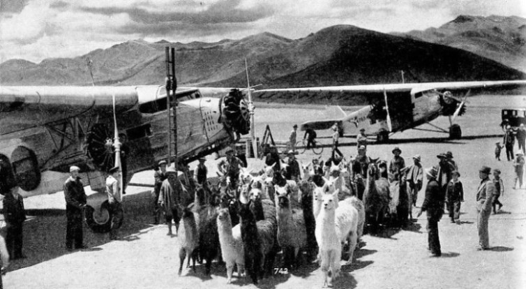
A remarkable example of what can be accomplished by air transport is afforded by the Peruvian development at Progresso in the province of Cotabambas — a wild and mountainous district some ninety miles south-west of the city of Cuzco. The mine itself lies in an almost inaccessible locality high up in the Andes, 12,800 feet above sea-level. A railway line runs within seventy miles of the mine, and is reached by a mountain track which can be traversed only by mule or llama. The journey takes about fourteen days to complete.
One of these animals can carry between 250 lb. and 300 lb., and since the track over the mountains is in some places merely a precipitous ledge, it is not possible to handle pieces of material or machinery more than 10 feet long. It is astonishing to think that the whole of the 1,000 tons of plant and equipment required for this mine was transported by air, two tons at a time. The time taken for the trip by air was only one hour, as compared with fourteen days by animal transport. Such a saving of time is a matter of great importance to any mining company. Apart from that, however, the aeroplane links the mine with civilization, so that it is not cut off in an emergency.
Thus it is that one of man's most ancient and important activities — that of gold mining — is deriving enormous benefits from his latest triumph, the conquest of the air.
OLD AND MODERN FORMS OF TRANSPORT. The planes used for transporting about 1,000 tons of equipment to the Progresso gold mine, in Peru, took only one hour to cover the seventy miles from the railway to the mine. The same journey by llama or mule takes about fourteen days and the loads are severely restricted in weight and size.


 This is a wonderfully simple idea and is sufficiently accurate to give a good indication of the general shape and nature of the country surveyed. The amount of movement of the screw can be accurately measured, and this is converted to the height by applying a simple formula. In effect, there is nothing complicated about the procedure, and a special technique has now been devised for eliminating those errors which are liable to creep in from various sources.