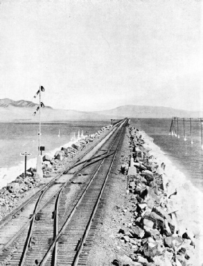

For twelve miles across the storm-swept Great Salt Lake in Utah the world’s longest trestle bridge was built by railway engineers to shorten by forty-three miles the route of the Central Pacific Railway
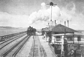
MIDLAKE STATION is equidistant from the shores of the western arm of the Great Salt Lake. The trestle section of the bridge required the timber of 38,256 trees, representing two square miles of forest. The work took two and a half years and cost £1,600,000.
WHEN the Central Pacific Railway, now part of the Southern Pacific system, was first built across the Middle West of the United States, the engineers found their path blocked by a large sheet of water -
As time went on and traffic increased, it was determined, if possible, to dispense with the roundabout route and to connect by a bridge the town of Ogden, to the east of the lake, with Lucin, to the west. The distance saved would be forty-
To connect Ogden and Lucin it was necessary to build bridges over two arms of the lake. One of these bridges is the longest trestle bridge in the world, the total length of trestle being just over twelve miles.
Great Salt Lake, however, is not an ordinary inland lake. It has an area of 1,720 square miles, is seventy-
When it was decided to bridge the lake in 1902 the problem was something entirely new to the engineering world, and in the execution of the work the engineers encountered many difficulties and had many surprises. The crossing, known as the Lucin Cut-
The engineers mapped out the path of the new track of the railway in an almost straight line from Ogden to the lake; thence over the water to a tongue of land, known as the Promontory, which divides the lake into two parts; thence directly on to the opposite shore, where the train, again on dry land, has a straight and easy run into Lucin. The distance between these two points is 102 miles by the new route, against 145 miles by the old route.
To carry out the plans of the engineers an army of 3,000 men braved the terrors of the desert and the storms of the lake. Before building began, however, many months were spent in collecting the necessary material and hauling it to the site. Mount-
Not even the engineers could properly estimate beforehand the amount of rock required, nor were they able to do so even after the work had begun, for the lake seemed to have a giant maw, which, for a time, swallowed everything dropped into it.
In building the bridge the principle followed was to raise embankments as far into the water as safety allowed, and then to bridge the rest of the line on piles. In some places the depth of water was 27 feet, and piles 60 feet long were driven firmly into the mud. Gravel was obtained from pits some three miles from the lake, and relays of men were kept busy for many months work-
Seven towing vessels, several small boats and a stern-
Across the eastern arm of the lake an embankment supports the bridge for nearly its entire length, a gap 600 feet wide being left for the passage of the Bear River. Across the western arm of the lake is a stretch of trestle twelve miles long, with embankment approaches of four miles at either end. On the eastern arm a temporary structure was first thrown across, from which travel trains dumped their loads to make a permanent foundation.
“Pile stations”, that is, little groups of piles driven firmly into the mud, were built in the deeper parts. On them pile-
Great variations in the consistency of the lake bottom were met with during the driving of the piles for the trestles. At times the blow of the “monkey” did not sink the pile more than an inch or two; at others a single impact would send it down as many feet. Again, a succession of blows might seem to be without effect, the pile having struck a hard stratum. Suddenly this would give way, and the pile would drop several feet. It often happened that a pile, after having been driven in from 30 to 50 feet, would rise two or three feet between the blows of the driver.
 EMBANKMENTS were built four miles out into the western arm of the Great Salt Lake from either shore to carry the Central pacific railway (now part of the Southern Pacific system). The rest of the crossing is made on trestles. The line is nearly level; the steepest gradient is 1 in 240.
In one place, about a mile from the eastern shore of the lake, a serious difficulty was encountered. The first pile, 28 feet long, was driven out of sight with a single blow. A second pile, also 28 feet long, set on top of the first, disappeared in a similar manner. At some time in the history of this great inland sea there had been here a colossal gulch, which has since been filled up with the slime and mud of the Bear River. For over six months tons and tons of solid rock were poured into this cavity, only to disappear out of sight and touch. The soft mud oozed from under this gigantic weight, allowing it to sink deeper and deeper until the engineers almost lost heart.
But perseverance conquered, and the “bottomless pit”, as the cavity was rightly named, was duly filled in. For a whole month over 2,500 tons of material a day were tossed into this quagmire.
The track was laid from the east and from the west, and the workmen met in the middle of the lake. “Stringers” were brought to them on rafts and lifted to the bridge by means of large cranes. Many thousands of logs for piles were kept in huge booms on the shores of the lake and towed, when needed, to the place where the pile drivers were at work. All told, 38,256 trees, representing two square miles of forest, were cut down to make piles for the great trestle.
During the building the men were housed in little encampments on the shores of the lake as near as possible to the bridge itself. All provisions and fresh water had to be brought to the camps daily by train, over distances varying from 80 to 130 miles. In the summer the heat was trying, for the whole region is a vast desert; in the winter there were sandstorms on land and gales on the lake.
The gales proved particularly trying. In one severe storm a number of men had a narrow escape. In the middle of the night some bunk-
Straight For Over 100 Miles
Happily, the occupants were rescued from their perilous position in the nick of time by a towing vessel and were taken safely to land. Gales were so common that material and machinery valued at over £20,000 were lost during the period of construction. For years after the engineers had completed their task the shores of the lake were lined with wreckage bearing testimony to the power of these storms, with the loss of boats, pile-
In the lengthy crossing there are several stations, Midlake Station being right in the centre of the lake. Passengers alight here to view the vast expanse of water, and trips can be taken by boat to islands in the lake. These islands are the homes of thousands of pelicans, seagulls and other birds. The waters of the lake are too salty to support ordinary fish life. Railings, breast high, have been placed on either side of the permanent way, and refuges have been built for workmen and pedestrians.
The cut-
